Pla del Mir - tour du lac d'Aude

vertygo
User
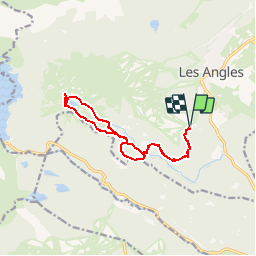

Length
12.9 km

Max alt
2198 m

Uphill gradient
416 m
Km-Effort
18.5 km

Min alt
1795 m

Downhill gradient
418 m
Boucle
Yes
Creation date :
2019-08-17 13:19:36.504
Updated on :
2019-08-17 13:28:05.364
3h52
Difficulty : Medium

FREE GPS app for hiking
 SityTrail
IGN / Geographical institutes
SityTrail Plus
The world is yours!
About
Trail Walking of 12.9 km to be discovered at Occitania, Pyrénées-Orientales, Les Angles. This trail is proposed by vertygo.
Description
parcours tracé après coup car GPX non sauvegardé
Photos


Positioning
Country:
France
Region :
Occitania
Department/Province :
Pyrénées-Orientales
Municipality :
Les Angles
Location:
Unknown
Start:(Dec)
Start:(UTM)
423290 ; 4712804 (31T) N.
Comments